Thursday, June 30, 2011

Galang Island, Place of Refuge Vietnam

Galang Island is an island with an area of ​​approximately 80 km ². Galang Island is an island in the municipality of Batam, Riau Islands province which is a series of three large islands connected by six bridges Barelang. The island is famous because of the Vietnamese refugee camps that occurred on a large scale in the year 1979 - 1996, or often known as the man canoe. The island is a concern by the UN and the international community since then. Galang refugee camps is now a tourist attraction and historical city of Batam, because it is relatively close to the island of Batam (about 7 miles).


During the period of 7 years, the agency UNHCR, the UN refugees gather this Vietnam war, which spread across several islands such as: the island of Natuna, Terempa, Anambas and surrounding islands into one in this place. This island used to have several kinds of facilities, such as: Red Cross clinic, administrative offices of the United Nations, where children's education, place of worship / temple, and a tomb for those who died of disease. During their stay in this place, the refugees learn English and other languages ​​as well as attending various training skills, pending a decision by the UN. The place was then officially closed by the United Nations in 1997.

In addition to this attraction, Galang island is also visited by many tourists on weekends because of Melur in the western coast of the island is quite beautiful. Have great historical value make this place frequently visited by tourists.

Wednesday, June 29, 2011

Bama Beach Banten

Bama beach is located 3 miles east of Post Bekol, the beach is frequently seen several species of monkeys are looking for crabs. Bama beach is clean beaches and surrounded by a lush mangrove forest, a coral reef for snorkelling activities in front of his beach guest house, and there is also a footpath around the coast and the wildlife monitoring to padang with Tower.
From the beach you can enjoy the sunrise Bama directly against the background of West Bali National Park one week in Pandeglang region that presents the beauty beneath the sea. You want to travel underwater visit Bama Coast. Facilities at the beach Bama has been prepared for snorkeling because many marine parks around the island and Liwungan Popole. And the beauty is guaranteed to make you impressed.

Tuesday, June 28, 2011

Kumala Island the Mahakam River Tourism

Kumala Island is an area on the Mahakam River delta which extends west of the City Tenggarong, Kutai regency. Beginning in 2000, Kumala Island is built into a tourist area. Kumala Island Park development carried out in stages and will continue to grow. Thus the public will get an additional tourist attraction that is representative in addition to the Museum Mulawarman Reservoir Sukarame Panji, Pondok Labu Village Culture in Tenggarong and Muara District Nusa Tuna on white sandy Muntai.


Kumala Island Nature Trail is about 27 km from Samarinda that can be reached via Bridge Kukar within approximately 30 minutes. While the city of Balikpapan has facilities Sepinggan Airport and the Port Semayang which is the access of air and sea transportation in East Kalimantan, is about 130 km that can be taken approximately 3 hours by road. In addition Kumala Island Park can also be reached by water transport through the Mahakam River.

Kumala Island tourist attraction located in the middle Mahakam River is a recreational park blend of modern technology and traditional culture. The island was formerly an area of ​​76 hectares is land and shrub beds. Currently, most areas are equipped with various facilities such as sky-high tower of 100 meters to enjoy the beauty of air, rail mini game area and cable car that connects with the mainland.

In this island there is a parr Resort, complete with swimming pool and facilities for those who want a break, that is the only cottage in the middle of the Mahakam River in the location of this island prepared for the Giant Aquarium fish dolphins, freshwater dolphin found only in the People's Republic of China and Brazil.


The vehicle contained in this island, among others:

1. Sky Tower as high as 75 Meters
Rates (Ticket Fee)
Adult: Rp. 7500, -
Children: Rp. 5.000, -

2. mini Train
Rates (Ticket Fee)
Adult: Rp. 5.000, -
Children: Rp. 2500, -

3. Merry Go Round
Rates (Ticket Fee)
Adult: Rp. 5.000, -
Children: Rp. 2500, -

4. Car Transport Tourism
Rates (Ticket Fee):
Adult: Rp. 1.000, -
Children: Rp. 1.000, -

5. Hanging Train (Cable Car)
Rates (Ticket Fee)
Adult: Rp. 7500, -
Children: Rp. 5.000, -

6. arena game
Rates (Ticket Fee)
Adult: Rp. 5.000, -
Children: Rp. 2500, -

7. trampoline
Rates (Ticket Fee)
Adult: Rp. 7500, -
Children: Rp. 5.000, -

Monday, June 27, 2011

Baths Cisolong Banten Tourism

Baths Cisolong is One of the natural bathing place that is no less beautiful and exciting. Cisolong baths are part of Carita beach has a source of volcanic rock springs located in the district Kaduhejo 10 km from City Pandeglang. This attraction is an attraction with background mountains are still green and the benefits are certainly a lot of hot water it produces. On this tour you can relax bath while enjoying the beautiful natural susana which has a very cool air accompanied by hot springs found there. If you come into this place you will definitely feel very comfortable, especially during the afternoon enjoying the beautiful sunset, is guaranteed to be very beautiful scenery.

Marina beach, Semarang

Marina beach is a recreational park in the northern city of Semarang. Marina beach is located in the northern city of Semarang, precisely in the way of Yos Sudarso approximately 4 miles from Tugumuda. Marina beach is located adjacent to the arena PrEP and Mareokoco so you can come visit once to three tourist attractions.


Marina beach is a recreational park. The beach is equipped with swimming pools, water sky, boat speed, and playground for children - children. On the morning of the area is often used for jogging exercise. Open every day at 06.00 for 24 hours.

On the Marina beach we can play as well as jet sky surfing, stom boat ride and boat or just relax while enjoying the beauty of the beach to rest and the waves. Marina beach is a very quiet place, many young people take advantage of the afternoon in time for release marina beach fatigue life of Semarang city. In addition, the small waves at this beach can make you free to swim.

Sunday, June 26, 2011

Baths Citaman attraction Pandeglang Banten Tourism

Baths Citaman attraction is a region that includes the most beautiful natural attractions in the world, one area in Pandeglang Banten Tourism. Citaman Baths Located in District Jiput. Locations natural attractions is the bathhouse, located in the Foot of Mount pulosari. Surrounding scenery is very beautiful. For those of you who love nature and tranquility travel Citaman bath is perfect for your visit. In addition, you can calm yourself in this place, if you enjoy it then this place will make you feel special.

Gunung Leuser National Park

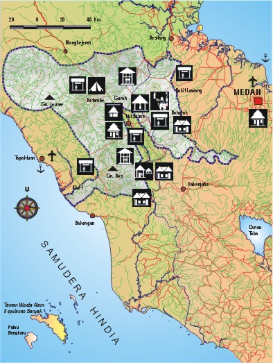
Gunung Leuser National Park is commonly abbreviated TNGL is a representative type of coastal forest ecosystems, and tropical rain forest lowlands to the mountains and became one of the Nature Conservation Areas in Indonesia, covering an area of ​​1,094,692 hectares which are located in two government administration of Aceh and North Sumatra Province. Gunung Leuser National Park is one defined by UNESCO as a Biosphere Reserve. Based on the Indonesia-Malaysia, also designated as a "Sister Park" with the State Parks National Park in Malaysia. Aceh Province which includes TNGL terdeliniasi Southwest Aceh District, Aceh Selatan, Aceh Singkil, Aceh Tenggara, Gayo Lues, Aceh Tamiang, while North Sumatra Province which includes TNGL terdeliniasi Dairi, Karo and Langkat.

This national park takes its name from the towering Mount Leuser with a height of 3404 meters above sea level in Aceh. This national park includes the original ecosystem of the coast to high mountains covered by tropical rain forests typical dense, managed by the zoning system is utilized for the purpose of research, science, education, culture, tourism, and recreation.

Almost the entire area is covered by thick forest Dipterocarpaceae with some rivers and waterfalls. There are rare plants and typical of a giant umbrella leaf (Johannesteijsmannia altifrons), Raflesia flower (Rafflesia atjehensis and R. micropylora) and Rhizanthes zippelnii which is the largest flower with a diameter of 1.5 meters. In addition, there is a unique plant or plant strangler fig.

Endangered and protected animals found in national parks, among others, introspective / orangutan (Pongo abelii), gibbon (Hylobates syndactylus syndactylus), Sumatran elephant (Elephas maximus sumatranus), Sumatran rhinoceros (Dicerorhinus sumatrensis sumatrensis), Sumatran tiger (Panthera tigris sumatrae), forest goat (Capricornis sumatraensis), hornbill (Buceros bicornis), sambar deer (Cervus unicolor), and cats (Prionailurus bengalensis sumatrana).

Mount Leuser National Park has 3 (three) functions, namely: a. protection of life support systems; b. preservation of species diversity of plants and animals and their ecosystems; c. sustainable use of biological resources and ecosystems.

Formal judicial existence of Gunung Leuser National Park for the first time stated in the announcement of the Minister of Agriculture Number: 811/Kpts/Um/II/1980 dated March 6, 1980 on the inauguration of five (5) National Parks in Indonesia, namely TN.Gunung Leuser, TN . Ujung Kulon, TN. Gede Pangrango, TN. Baluran, and TN. Komodo. Based on the announcement of the Minister of Agriculture, the area designated TN. Gunung Leuser is 792,675 ha. The announcement was followed up by the Ministry of Agriculture Directorate General of Forestry Letter Number: 719/Dj/VII/1/80, dated March 7, 1980, addressed to the Sub Hall KPA Gunung Leuser. In the letter stated that the management authority granted TN status. Gunung Leuser to the Sub Hall KPA Gunung Leuser.

As the basic legality in conjunction with the inauguration of forest areas has issued Ministerial Decree number: 276/Kpts-II/1997 on the appointment of TN. Gunung Leuser area of ​​1,094,692 hectares located in the Special Province of Aceh and North Sumatra. The decision stated that the TN. Gunung Leuser consists of a combination of:
1. Gunung Leuser Wildlife Reserve: 416,500 ha
2. Kluet Wildlife Refuge: 20,000 acres
3. Wildlife West Langkat: 51,000 hectares
4. Wildlife South Langkat: 82,985 hectares
5. Sekundur Wildlife Refuge: 60,600 acres
6. Wildlife KAPPI: 142,800 hectares
7. Gurah Park: 9200 acres
8. Forest Protection and Limited Production Forest: 292,707 hectares

According to Regulation of the Minister of Forestry Number: P.03/Menhut-II/2007, TNGL is currently the manager of Technical Implementation Unit (UPT) Directorate General of Forest Protection and Nature Conservation (DG PHKA) Great Hall of the Ministry of Forestry of the Gunung Leuser National Park (BBTNGL) led by Head of Central (echelon II).

One of the objects and the Fascination Nature (ODTWA) famous in the region is TNGL Sumatran Orangutan Observation Centre - Bukit Lawang in Natural Area Tourism Bukit Lawang - Bohorok, Langkat, North Sumatra.

The other hand, the park also received attention because of the rampant cases of illegal felling of trees in some locations that violates the reservation environment.

Most of the area TNGL has a steep topography and soil structure and texture are prone to landslides. This was evident during the flood that destroyed the tourist area of ​​Bukit Lawang nature a few years ago. To further keep TNGL from further damage will be established an area known as the Leuser Ecosystem. The area which has an area covering 2.6 million hectares of this area is more flat around TNGL and serves as a buffer (buffer).

Some locations / attractions to visit:

  • Gurah. See and enjoy the scenery, canyons, hot springs, lakes, waterfalls, wildlife observation and plants such as flowers Raflesia, orangutans, birds, snakes and butterflies.
  • Bohorok. Place orangutan rehabilitation activities and natural attractions in the form of panoramic river, camping and bird watching.
  • Kluet. Boating on rivers and lakes, trekking in the coastal forest and cave tours. This area is the habitat of Sumatran tigers.
  • Sekundur. Camping, cave tours and wildlife observation.
  • Ketambe and Suak Carambola.
  • Research primates and other wildlife researcher who comes home and library.
  • Gunung Leuser (3404 m asl) and Mt. Pecan (3314 m asl). Climbing and mountaineering.
  • Rafting on the Alas River. Rafting of Gurah-Muara Situlen-wave for three days.
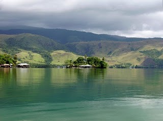
  • Orangutan (Pongo pygmaeus) Cultural attractions outside the Park is Lake Toba Festival in June at Lake Toba and Malay Culture Festival in July in Medan.
The best visiting season: June / d in October each year.

How to reach the location: Medan-Kutacane is ± 240 km or 8 hours by car, Kutacane-Gurah/Ketambe within ± 35 km or 30 minutes by car, Medan-Bohorok/Bukit Lawang is ± 60 km or 1 hour by car, Medan- Sei Betung / Sekundur is ± 150 km or 2 hours by car, Medan-Tapaktuan is ± 260 km or 10 hours by car.

Saturday, June 25, 2011

Ujung Kulon National Park

Ujung Kulon National Park is the world's most beautiful tourist areas, one area in Pandeglang Tour. Endangered places java one-horned rhinoceros satu.TNUK badaknya which turned out to be famous for remaining in the 40s tail Ujung Kulon area located in the district of the Well about 4 hours overland journey from the city Jakarta. The specialty of this place is the oldest national park in Indonesia, the area is equipped with telecommunication networks, electricity, and clean water, lodging options there are motels, hotels, homestay, and cottages. For those of you who like the quiet atmosphere of rare species and Ujung Kulon National Park is perfect for your visit.

Dimples Cape Coast

Dimples Cape Coast is a coastal location of land that juts like the tip dimples the sea. Many exciting water games on this beach, there jetsky, snorkeling, fishing, boating, hotels, marinas, restaurants, cafes and other coastal areas of Tanjung lain.Memasuki Dimples, we are exposed to green lawns with coconut trees that spread out neatly. Then there it the turquoise coast with waves that are not so great. Sprinkled with white sand and crystal clear sea water rather make this beach looks clean. Scenery with the wind gusts are not so tight, it could be a place to relax and make us feel happier.

Friday, June 24, 2011

Misool island One of Amazing Island in Raja Ampat

Misool island situated in the Raja Ampat region in the southwest mainland of Irian Jaya, bordering the sea spooky. This area is located in western Papua bird's head and close to the town of sliding. Regional inventory of the eastern part of the island and limited by the geographic coordinates between 01,040 '- 01,055' south latitude and 13 010 '- 130025' east longitude.


Misool divided into two parts namely the southern and eastern Misool Misool west. The area is also famous with the diversity of cultures, customs, sea and land is so famous in the world. Misool including the world's coral triangle area and dozens of many ornamental fish present in the sea which is about 75% of ornamental fish and the coral triangle also present in this Misool area. And this area also has a very wide open seas all, making it the traffic lane that large animals like whales and octopuses. According to information from local people that the octopus is often found at night while the whale is found in the daytime, so the area is known or virtually Misool a region full of mysterious because there are still many marine animals that besar2 in this area and which is endangered in world.

This area is composed by a series of stratigraphic sedimentary rocks of Tertiary and Quaternary age in the order from old to young is Limestone Zaag, Batunapal Kasim, Openta Limestone, Limestone Atkari and Alluvial deposits. Unit coal deposits found in Plio-old Atkari Limestone and Unit Batunapal Plistosen Kasim Early Miocene - Middle Miocene.

Comfortable and Beautiful rumoh Aceh

The province has 13 indigenous tribes, namely: Aceh, Gayo, Aneuk Jamee, Singkil, Alas, Tamiang, Kluet, Devayan, Sigulai, Pakpak, Haloban, Lekon and Nias.

Most of the population adheres to Islam in Aceh. Of the 13 native tribes in Aceh Nias only tribe that not all of them embraced Islam.


Other religions embraced by the population in Aceh is the Christian religion professed by the Batak ethnic immigrants and some residents are mostly Chinese Hakka tribes. While others still adhere to the Confucian religion.

In addition the province has a privilege compared to other provinces, because the Islamic Shari'a in the province apply to most citizens who embraced Islam. Our ancestors had to design a building that cares about the condition of the surrounding nature by creating an earthquake-resistant houses. Traditional Acehnese house by local residents called rumoh Aceh. The shape is uniform, ie rectangular lengthwise from east to west. That said, the location of the elongated was chosen to facilitate the determination of the direction of Qibla.

In terms of carvings, rumoh Aceh in every district in Aceh province are not the same. They each have different kinds of carvings. According to Mohammad Isa, villagers Lamsiem, the current number of traditional houses in the village will be decreasing because of the cost required to make rumoh Aceh is far more expensive than building a normal house / modern. The cost of treatment was no less drain bag.


Whereas in the past the majority of residents in residential average live in traditional houses made of wood and thatched it. Even those who were well off, decorate the house with wood carvings and other ornaments. Meanwhile, residents who live hand to mouth, enough to build a wooden house with no carving and ornamentation.

Not surprising, because until the 1980s people were still easy to get wood so that the cost to build affordable rumoh Aceh at that time. But, now cost to build a traditional house has been doubled from the cost of a modern home.

The main components

Although in each district / city is different details, rumoh Aceh in general have the same main components. The main components rumoh Aceh was revealed in the book Cultural Communities in Aceh. The components are:

-Seuramou-keu (front porch), ie a room that serves to receive male guests, and is located in front of the house. This room is also both a bed and dining male guests.

-Seuramou-likoot (back porch), the main function of this room is to receive female guests. Located at the rear of the house. Like the foyer, the foyer can also be both a bed and dining room of women.

- Rumoh-Inong (homestead), the location of this room between the front porch and back porch. His position is higher than the second platform. Main house is divided into two rooms. Both are separated alley or also called vine that connects the front porch and back porch.

- Rumoh-Dapu (kitchen), where the kitchen is usually adjacent or connected to the back porch. The floor is slightly lower than the floor back porch.

- Seulasa (terrace), terrace house situated in the very front. Patio attached to the front porch.

- Kroong-padee (granary), was separated from the main building, but still in the yard. It lies to the rear, side, or even in front of the house.

- Keupaleh (gate), this fact does not include the general characteristics due to the use of gates in general rich people's homes or community leaders. The gate was made of wood and on it dipayungi booth.

- Tamee (pole), the power pole is a major cornerstone of this traditional house. Round-shaped wooden pole with a diameter of 20-35 cm 150-170 cm tall it could amount to 16, 20, 24, or 28 rods. The existence of these poles facilitate the process of moving the house without having to unpack.

In the past, Aceh rumoh roof made of thatch. In case of fire, it's thatched roof can be lowered simply by cutting one of the straps are made of rattan or palm fiber.

First, in front of the stairs to the house, usually terdepat jars. This object serves to store water for washing the feet of each going into the house.

One part is also important to rumoh Aceh is the ladder. Typically, the staircase is located under the house. Everyone should be headed in the door with my head so open and enter.

The number of the steps, always odd. One more typical of the building rumoh Aceh is made without nails.

To associate the log with one another enough to use pegs or straps of rattan or palm fiber. Most of the Acehnese people, sometimes also makes the yard as a place of burial.

In more modern, traditional Acehnese houses now from various districts / cities enshrined its model in the Garden Queen Safiatuddin, Banda Aceh.

Thursday, June 23, 2011

Waigeo Island One of the Amazing Raja Ampat Island

Waigeo Island is an island in West Papua, Indonesia. The island is also known by the name or Waigiu amberi. Waigeo Island is the largest of the four main islands of Raja Ampat Islands. The island is located between the island of Halmahera and New Guinea with a distance of about 65 km northwest of the island of Papua.
Big island surrounding the island of Salawati, Batanta Island, and Island Misool.Luas island 3155 km ², with the highest point 1000 m. The distance between the west to east about 110 km, and north to south about 50 miles. Wasai city located in the western part of the island and is the capital of the Raja Ampat regency. Since 1997, the island has become a cultured pearl that is owned by Australian company Pacific Atlas.

Carita Beach The Beautifull Beach in Banten

Carita Beach is one of the tourist area located on the western tip of Java island which is famous for its beautiful beaches, as well as having its advantages and its own charm, but is rich with cultural attractions Carita Beach also offers the charm of a million sea tourism and nature tourism are very impressive. Tourist area located on the edge of Sunda Strait has become an alternative for people in Jakarta and surrounding areas to dispose of fatigue after a week doing routine activities that would waste energy and mind, with a vacation to Carita beach you will forget for a moment every day routine that you do.


In this Carita beach you can do many activities like swimming in the ocean because the waves are not big, fishing, playing Jetsky, banana boat, Skateboarding, beach volleyball, boating, or just to sit down - sit down to enjoy the waves and sea breeze. Besides offering beautiful beaches, Carita Beach has a choice of hotels along the lip of the beach, ranging from jasmine-class hotels to grade all-star at Carita Beach, with distinctive features and advantages that are not owned by another hotel. In addition, this beach will look very beautiful if you come in the afternoon before sunset, then proceed to enjoy the beautiful night on this beach.Krakatau mountain beauty can also be enjoyed at this beach, so do not worry and do not hesitate to come to this beach.

Wednesday, June 22, 2011

White Sand Beach Ciantir, The Nature Beach in Banten

White Sand Beach Ciantir also called Sawarna beach because the beach is located in the Village District Sawarna Bayah Lebak Banten. The distance from the capital city of Lebak 140 Km. To go to this beach you need not worry because the road to this beach is very adequate. Ciantir beach or beach Sawarna still classified as very natural and has the potential development of natural tourist attraction with its natural beauty, the natural state of flora and fauna, heritage, arts and culture held Sawarna Village is a natural resource that will make this beach very crowded for visited.

Lake Sentani The Biggest Lake in Papua Indonesia

Lake Sentani is located under the slopes of the Mountains Nature Reserve Cycloops which has an area of about 245,000 hectares and extends between Jayapura Jayapura regency, Papua. Lake Sentani, which has an area of about 9360 hectares and located at an altitude of + 75 meters above sea level is one of the largest lake in Papua and Indonesia. Lake Sentani developed for freshwater fish farming.

It is used to increase local community nutrition and one source of local revenue. With the potential large-scale water discharge, the Lake Sentani to clear land for cultivation of various species of freshwater fish, which will be able to meet market demand in Papua and even out of Papua. Not only that Lake Sentani also be a place you relax with your family during the holidays.

Tuesday, June 21, 2011

Manuk Island beach

Manuk Island beach located in District Bayah, Lebak district stringing with Taraje Coral beach but the beach is white sand beach free of rocks. Coastal beaches are wide and gently sloping with the waves being, is safe for swimming and surfing. From the beach is 2 km Coral Taraje.

Jayawijaya Mountains, the Highest Mountain in Indonesia

Indonesia is a country known for having the most world's volcanoes. Jayawijaya Mountains is the name for the mountain range that stretched lengthwise in the center of the province of West Papua to Papua New Guinea Newguinea on. Rows of mountains that has some the highest peaks in Indonesia is formed by removal of the sea floor thousands of years ago. Although located at an altitude of 4800 meters and includes the highest mountain in Indonesia, fossilized sea shells, for example can be seen in limestone and clastic rocks contained in the Jayawijaya Mountains. Therefore, besides being a paradise of the climbers, Jayawijaya Mountains is also a paradise researchers geological world.


Besides known as Puncak Jaya, the highest peak is also known as Carstenz Pyramide, or the Carstensz Peak. The name was taken from an adventurer from the Netherlands, namely in January Carstensz, who first saw the snowy peaks in the tropics, specifically in New Guinea. The observation was made by Jan Crastensz through a ship in 1623. Since not be proved by direct observation, the report was considered absurd. Because, for Europeans, found the snowy mountains in the tropics is something that is impossible.

Truth Carstensz report revealed after nearly three hundred years later, when in 1899 a Dutch expedition to New Guinea make a map and find snow-covered mountain peaks as reported by Crastensz. In honor of Carstensz, the mountaintop is then named as the name implies. While the designation Jayawijaya Peak is pemeberian President Sukarno after successfully embrace the sovereignty of West Papua from the Netherlands. This name meaning "summit victory", as an expression of gratitude for the unification of West Papua with the Unitary Republic of Indonesia.


Jayawijaya Mountains is also the only mountain and mountain in Indonesia, which has a peak covered with eternal snow. Although not all peaks of the cluster Jayawijaya Mountains that has snow. Snow is owned by several peaks even at this time is lost due to climate change globally. Lots of things are very beautiful in Indonesia and this has made Indonesia a place of Heaven Tour.

Monday, June 20, 2011

Hot water attractions in Banten Indonesia

Hot water attractions are located in the Village District Cipanas Cipanas Lebak / in highway Bogor ± 32 km from the City Rangkasbitung (Capital Lebak). Can be accessed from Rangkasbitung or from Bogor (Jasinga) within 28 km with a strategic location on the edge of the highway.


Fasillitas attractions available in Lebak Cipanas hot water, among others:
Wading pool / swimming pool measuring 25 x 20 M, with a water temperature of 40 º C - 60 º C.
Pool / hot tub 4 units a bathroom with a water supply that flows continuously.

Home Stay in the society around.
Bath / soak in hot tubs helpful:
Cipanas hot water containing a relatively high sulfur content so it is very effective for curing various skin diseases including acne cure.
Can cure asthma, bone diseases, rheumatism, gout and others.
Frequent bathing / soaking in hot tubs Cipanas body into a fit and youthful.
Discharge water produced from several sources of hot water 6 liters / second which is then stored in advance into the tank before then flowed into a wading pool / swimming pool or the main

Bedugul, Bali island Indonesia

Bedugul is a tourist attraction in Bali which is located in a mountainous area that has the atmosphere cool and comfortable, can enjoy the beauty of the lake and Ulun Danu Beratan, located in the village of Candi Kuning, Baturiti District, Tabanan. Bedugul Attraction is approximately 70 miles, or about 2.5 hours from Ngurah Rai Airport. Buildings located in Bedugul tourist area is a building tempo and somewhat old-fashioned, but all physical objec still clean and neatly arranged. Bedugul offers a soothing atmosphere and beautiful hills Tamablingan.Bedugul lake located at an altitude 1250 meters above sea level, as it is located at an altitude of 1250 meters above sea level, Bedugul has a very cool air and sometimes on the blanket of fog.


Not surprisingly, this region has long been known as a resort and a very famous vacation spot. In colonial times, many Dutch people who built the guesthouse there with a view overlooking the lake. Now, local communities had to build places of rest in there. Some are used alone, some are leased. The natural beauty of the mountains and Lake Beratan is clean, in the middle there is a Ulun Danu temple which is a shrine to the Sang Hyang Goddess Danu as a giver of fertility, it would be a shame if the miss.

Ulun danu - Bedugul

Travelers can enjoy a relaxing time with a walk, rent a boat to the temple, many tourists visit here during the holiday season. There in Bedugul Botanical Gardens which is one of them in Bali, various types of fruits fruits and vegetables thrive in this area. Locals sell their garden in the local market and also sold to other areas in Bali. Here also prepared boats or canoes are rented for pengunjug to better enjoy the beauty of Lake Beratan. In this Bedugul tourist areas there are also small stalls for souvenirs. Many places of interest in this Bedugul, so guaranteed you'll enjoy this place.

Sunday, June 19, 2011

Waterfall Spring Madness

1. overview

Waterfall Spring Madness, is one of the waterfalls located in Lombok West Nusa Tenggara. Called the Gila waterfall spring because the locals do not stumbled across this waterfall while the population of lions hunting in a disruptive Mad kampungdan then go into the woods. This waterfall has a height of 31 meters. This waterfall comes off the cliff and fell in the river kemidian contained under this waterfall.


2. feature

The waterfall is located 600 meters above sea level, a touch of nature that are categorized as far from the urban feel, beautiful scenery and charming serata the fresh air can make you feel very peaceful life. There was also a waterfall also has a mystery that the waterfall can make us stay young.

location

The waterfall is located in the north of Central Lombok, West Nusa southeast. Precisely in Senaru Village, Kecamatan Bayan. This location is located in the region of Mount Rinjani Yang became the third highest mountain in Indonesia.

3. access

To reach this location usually takes 2 hours from Mataram Airport Selaparang. To Achieve this place tourists usually haru About a 15 minute walk.

4. Admission

You just pay Rp. 5000 Places To Go to this tour

Small Peacock Island

Small Peacock Island is located ± 1 km next to the power port of Merak and within ± 10 menitdengan using motor boats. This island has a total area of ​​4.62 ha and is a large cluster of peacock island there are a variety of faucets, the spread of rocks and plants and trees. Sights of the island towards the port of Merak and the Sunda Strait that against the background mountains are very beautiful.
In both these pualu (Action Plan Zone B), planned to be built "Cable Car" by the main station area of ​​the Marina beach Peacock, so that the traveler will be able to see the activities of the port of Merak, ship / boat that was sailing and sea views Sunda strait. As well as around the Peacock Mountains. Peacock large island, visitors can get out of the Cable Car and headed Restaurant located above the station Cable Car to enjoy dishes Sea Food, miscellaneous food / beverage while enjoying the surrounding scenery. It will also isediakan "big Binoculars" that could see Sumatrea Island, Mount Karakatau, Mount Batur and the surrounding landscape. While on the island of Small Peacock visitors can see the Aquarium and marine biota and can enjoy the food / drink at the restaurant under the sea which is the first underwater restaurant in Indonesia. Also in this area will also be in a sense become "Tourism Village / Village Fisherman" and beach recreation and cultural tourism development area of ​​the original city of Cilegon.

Saturday, June 18, 2011

Large Peacock Island

Large Peacock Island is located exactly (± 500 M) in front of the port of Merak crossing - Bakauheni (ASDP), with area about 20 ha. This island there are Flora (Various plants and trees) and fauna (monkeys, snakes, and various shells), nature is still beautiful and uninhabited, there are rocks and coral sites of Mount Krakatoa in 1883 Tsunami. This island also serves as a wave barrier to the port of Merak and serve as a protected area which preserved its existence. Can be taken approximately 15 minutes from the center of Cilegon. and ± 5 minutes to cross by boat motors.

Waterfall Yarn Nets the Beautiful Waterfall

Waterfall Yarn Nets is one of the waterfalls located on the island of Lombok. Lombok Island is one island in Indonesia that has a lot of places are very impressive. As an island rich in natural scenery is pretty and charming, wherever you walk on this island you will definitely menemukanpemandangan beautiful nature and fascinating. And one of the waterfalls on the island of Lombok is the Waterfall Yarn Nets Being located near the waterfall of the Mind Stokel is located in the village Aik Berik, North Kliang Stone, Nusat Middle East Lombok Barat.


Nets Waterfall is one of the sights that you should visit. To reach the waterfall inianda will pass through a beautiful stretch of pesawahan hambaran hill with a beautiful and high mountain Rinjani. The flow of water in the waterfall is not so heavy so is suitable for you who want to bathe in this waterfall. Butter is also a waterfall that trickled through the leaves is believed by local people to cure various diseases and make you more youthful. In addition, you just spent Rp 3,000 to enjoy the beauty of this waterfall.

Friday, June 17, 2011

Mount Batur, Banten Indonesia

Mount Batur is located Pulomerak sub region, is a tourist destination Agro, which is oriented special interest tours, such as: Hiking, Camping Area, Flora and Fauna Study, Jogging, Laiyang hanging or hang gliding. Road conditions from the bottom up to the lighthouse and the paved well, welcoming residents in the village of Mount Batur with suave always decorated with a smile that we often encounter towards the top of the mountain.
Architecture-syaf bersyaf house grove and surrounded by established trees and the cool beauty of nature as mountains are evidence of how fertile the land of Mount Batur. From the top of the mountain we can enjoy the beautiful views, it would seem the industrial park, the sea strait of Sunda, houses in the area below, Cilegon and Merak Port.

When the night of the Mount is a separate attraction lights sparkle from the Ferry boats and speed boats as well as the area is very charming, moonlight bounces off the ripples of silvery sea. Available also at the foot of the mountain accommodation means that the hotel and restaurant classy to star jasmine. Mount Batur can be taken approximately 10 minutes from downtown Cilegon with a distance of ± 8 km.

Saluopa Waterfall, The Amazing Waterfall in Central Sulawesi

Saluopa Waterfall is one of the interesting sights in the Central Sulawesi village of precisely located in Tonusu, North Pamona, Poso, Central Sulawesi. This waterfall has 12 levels. From one level to the next level there is interest from the stone, making it easier for visitors to reach the top level. In addition, under the waterfall there are pools that have very clear water.


It is also near the waterfall there are tropical forests with diverse flora and fauna therein. it is also at this location there is a small bridge that must pass to get to the waterfall.

The waterfall is located about 12 km from the western town of Tentena, From this town to the waterfall can be reached using a four-wheel vehicles, then you touched skitar walk 500 meters to reach this waterfall.

Thursday, June 16, 2011

Gunung Batu Lawang

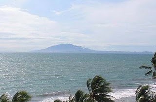
Gunung Batu Lawang is a mountain with the fresh air is not mixed with pollution. This hill is perfect for hiking enthusiasts visited, because the terrain is more gentle and natural beauty that adorn the whole way.

From this mountain you can see the sights in the city of Cilegon. Mountain in the region Gerem - Peacock with an unspoiled natural environment, cool and fresh is the main attraction. As the appeal of these attractions is the panoramic beauty of Cilegon. Although the height does not exceed 100 meters, but still original and natural environment and fresh air, which makes us want to linger on these attractions.

For those of you who like the challenge can visit the Batu Lawang mountain attractions. From the mountain will look beautiful and stunning buildings.

Ngebel Lake the Mysterius Lake


East Java is a pretty interesting places on the island of Java, Lots of tourist attractions in East Java and One of them is Lake Ngebel. The lake is called Lake Ngebel because Lake is located in the district area Ngebel. Which is located about 24 km north-east Ponogoro, East Java. The lake is located on the slopes Ngebel Wilis mountain with an altitude of 734 meters above sea level and temperature of 22-32 Celsius.


With a surface area of ​​about 1.5 km, the lake is surrounded by roads Ngebel along the 5 km. This lake has an amazing panoramic view, the cool air with the natural condition of the girl who kept a million potential to be explored.

In the lake there are also a variety of fish, one of which is a protected fish varieties. For that purpose, accommodation facilities are also available for visitors who want to spend the night. The facility is managed by local governments and private companies. According to the legend that developed in the community, Ngebel lake formed by the story of the serpent named "New k-ping".

When taking a snake that he was meditating and did not accidentally cut into pieces by the people around to eat. Mysterious snake turned into a child who later visited the community and make a contest for the repeal ribs glued to the ground with him. No one has managed to carry it out.

After that he pulled out a rib, and rib holes out of the water which then becomes a large pool of stagnant and become a lake Ngebel. Ngebel lake seems to have an important role in the history of Ponorogo, because one of the founders of Ponorogo, Batoro Katong, before the greatness of Islam in Ponogoro District has removed himself in the pond near the lake Ngebel. At this time, known as the pool / Kucur Batoro. And still there banyal yan interesting thing of this lake is unknown.